Bhaga Valley : Explore Mighty Baralacha La with Serene Lakes

Hello all,
I have read somewhere, “In the end, it doesn’t matter how many breaths you take, but how many moments take your breath away.”
And the second day of our Lahaul trip was like that. We were awestruck by the sheer wonder of nature, what we call the mighty Himalayas or the third pole. After staying a day in fantastic Tinan Valley, we were on our way to the most awaited day of the trip. we were exhilarated about this because we were going in the snow! And that too at appx 16,000 feet, and that too without trekking!! .
About Bhaga / Tod Valley:
The Tod Valley starts from Darcha and extends till Sarchu, where Himachal Pradesh ends, and Leh-Ladakh begins. So this is the prominent part of Leh-Manali Highway and the most dramatic one.
Major tourist places:
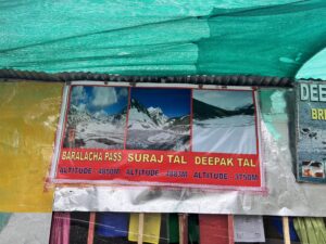
Stunning lakes: Deepak Tal and Suraj Tal
Incredible Passes: Baralacha La Pass and Shinku La Pass.
We left early, at around 7 am, from Phuktal as the weather was still windy and traffic could be heavy after Darcha. We passed from Gahar Valley, but we didn’t stop anywhere in between.
Darcha
Along the road, Jispa is the last inhabited place of Himachal Pradesh. There are a few dhabas and campsites along the way. Jispa is a beautiful small village on the banks of the Bhaga River at an altitude of over 10,800 ft. Darcha is a major check post where every vehicle has to make an entry before moving further ahead, and they have to notify whether they are going forward to Leh or just for a day trip. They record all the cars, and if day-trip vehicles don’t return, they have to look for them. They limit the entry of vehicles upto 12’o clock in the afternoon when there is heavy traffic. We went there in June first week and there was a massive line of trucks, and many of them would have to wait for 24 hours in that weather. After crossing the Darcha Bridge, which is also the longest bridge in the state and known as Barsi Bridge, few kilometres later, you will reach to Deepak Tal.
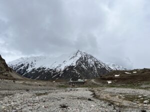
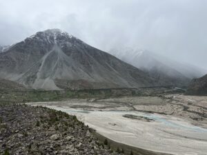
The landscape changes dramatically once you cross Darcha Bridge. Now it turned utterly barren. The trees are telling you goodbye, and the snowy mountains welcome you with warm hugs to your eyes.
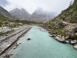
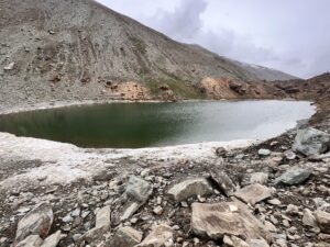
Deepak Tal / Dozom Tso:
It is a small beautiful water body in the valley along the highway as you pass between Leh and Manali. The water is calm and crystal blue, reflecting mighty mountains. The surroundings are so beautiful that you can easily sit there and soak in the soothing vibes. Lake is formed by melting glaciers in summer and freezes completely in winter. There are few cafes / Dhaba on either side of the road here.
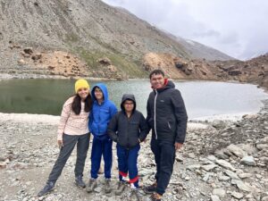
Located at: Patsio, where there were few campsites. We sat there for a while on the tranquil river bank.
Height: 3,750m above sea level / 12,300 ft,
Distance –
from Jispa: 21 km
from Keylong – 43 km
from Darcha bridge – 16 km
Zing zang bar:
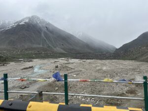
Further ahead of the Deepak Tal is the Zing Zing Bar which is at a height of almost 15,000 feet and is famous for notorious nalas. It is a depot for Border Roads Organization’s road-building camp and cafe. There are a few stretches where the roads were being repaired for the summer season. There are a lot of streams and small brooks which flow on the roads, so be careful while driving, which is why tourists are not allowed beyond Darcha after noon.
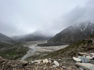
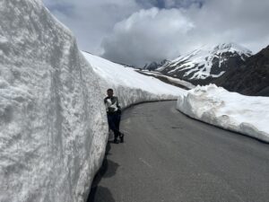
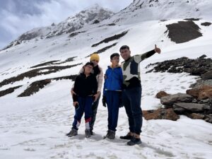
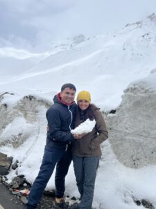
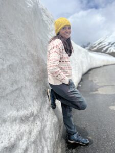
From here, you will enter the picturesque roads with stunning snow walls on either side. And here, my dream of visiting those roads came true! You want to get down at every turn and take a picture!

It was like we were in the middle of nowhere. The mountains we usually see from afar during our other treks and trips are now with us! We were between those snow-laden mountains, and we could not even tell where the mountain peaks ended and where the drifting clouds started. It was like we were in a dreamland, and the snowfall started. It was gentle, with calm winds blowing our minds. Satva was feeling sleepy, but we three were in our wonderlands! Nobody spoke a word because our surroundings spellbound us.


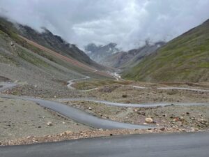
And then we met the harsh reality of this highway. A traffic jam! Yes, at 15,000 feet, we were stuck in a bottleneck that could go on for hours. The road was single-lane from that point onward. Suraj Tal was just a kilometre ahead. Mr Shubham was sure that if we wanted to head to Suraj Tal and Baralacha la, we would have to wait in that traffic. We won’t be allowed to return before 4 pm as all the trucks from Darcha would be allowed to go first on their way to Leh, and then the return traffic will start. He told me that Suraj Tal is any way frozen. You won’t be able to see the beauty of the lake. Considering the changing winds and starting of snowfall, we decided to return.

But let me guide you with little information about Suraj Tal and Baralacha La pass. We hope you can finish your journey when you go there and we hope we can also travel there again!
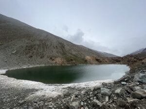
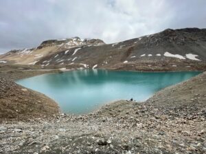
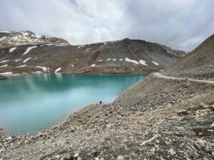
Suraj Tal Lake / Tso Kamtsi:
It is one of the best high-altitude lakes in the country. According to the name, it means the lake of the Sun God. It is believed that taking a dip here in Suraj Tal will cleanse all your sins. The Indian army also calls it Vishal Tal in memory of a soldier who died in this region. Suraj Tal Lake is fed by the Bhaga River, which lies below the summit of Baralacha Pass.
 From archives of Hippie in Hills
Altitude: one of the leading high altitude lakes, 4950m / 16,043 ft above sea level.
Distance:
72 km from Keylong
3 km before Bara-lacha la pass.
Deepak Tal to Suraj Tal: 28 kilometers
Trek to Suraj Tal:
It starts from Zing Zang bar. The trail runs along the Bhaga River for 3 km, and after that, you have to climb 2.5 km. Further, after a steep climb downhill, you will reach here.
The Lake is the source of the Bhaga River, your constant companion in this valley. The lake is not just a roadside like Deepak Tal, you have to go a little down, and it is not always easy to reach there. The lake remains frozen during most months of the year. But when the snow melts, the colours of the lake are impeccable.
 From archives of Hippie in Hills
Story of Suraj Tal:
There is a folktale associated with this lake. It is said that Bhaga was the only son of the Sun God, and Chandra, the moon’s daughter, met first at the Baralacha La and instantly fell in love. But the sun and Moon gods were against their love as they wanted their children to spread light during day and night, respectively. So Chandra and Bhaga decided to elope and meet at the Baralacha la pass. Chandra arrived first, landed on the earth where present Chandra Tal Lake is located, and Bhaga arrived where Suraj Tal is. They both met at Tandi. The route Chandra took was 115 km, and she was intelligent, agile and active, and she quickly found her way (present Chandra River). The course which Bhaga took was 60 km but was challenging, so he came with a great struggle through narrow valleys and gorges (current Bhaga river). But eventually, both rivers met at Tandi, where the marriage of Chandra and Bhaga took place.
Baralacha La Pass:
The word’ Baralacha’ is from the Tibetan language and means ‘a pass where crossroads meet. The high mountain pass is the meeting point of the roads leading to Spiti, Ladakh and Zanskar. It is one of the most challenging and highest motorable passes on the Manali Leh route. It receives heavy snowfall and closes in late September / early October, and opens in May end. However, it can snow at any time of the year. It also connects Pir Panjal, Zanskar and Great Himalayan mountain ranges.

Altitude: 4890 mts or 16,040 ft.
Distance:
75 Km from Keylong.
145 km from Manali
3 km ahead of Suraj Tal
Baralacha La Weather
During the summer, the temperature is around 8-13 degrees during the day and below 5 degrees at night, while in winter, the temperature can go up to -25 degrees. It is always cold and windy as it is a high mountain pass. It is covered with snow almost all year around.
Trekking to Baralacha La:
The pass is easily accessible via roads, but that doesn’t lessen the trekking option for explorers and adventure lovers. Usually, they follow the route of Manali –> Batal –> Chandrataal –> Topko Gingma –> Topko Yongma –> Baralacha La. It usually takes a week to pass high mountains and cross a few glacial rivers.
Permits for Baralacha Pass
You must show your identity proof like passports, voter ID cards or Aadhar cards. Foreign visitors need to show their passports and visas.

Best time to visit Bhaga Valley:
May and June – you will still find snow in the surroundings, and the weather is pleasant
July and August – should be avoided as you might face landslides with heavy rainfall.
September – again, starting off the Autumn. You might not get snow, but the weather will be pleasant.
October to May – the higher mountains at Baralacha La Pass usually receive snowfall from the start of October, so you need to check the condition before going. Winters are very harsh here, and the pass will be closed
If you are going to Baralacha La pass, then it should be crossed during the daytime, as during the night, the winds are colder, and the weather is harsher.
Mobile Network:
There is no mobile network after Keylong. Only BSNL and Jio users will get the network till Keylong. There is no Vodafone, Idea, and other network beyond Solang Valley.
Essential Tips:
- Please, please check the weather.
- Follow the instructions of your guide or driver and trust them unthinkingly. If they tell you to return, you do that.
- Start your journey early in the morning to reach the pass by noon.
- The last food stall is at Zing zang bar, and the previous hospital is at Keylong.
- Drink enough water and drink constantly at regular intervals. You can’t take the risk of dehydration.
- If you feel any signs and symptoms of acute mountain sickness, return immediately.
- Don’t stay for too long at the pass.
- There are small streams with few rivulets crossings along the roads, so that they might get risky.
- Pack enough warm clothes, as it is always windy and cold, even in summer.
- If possible, stay at Sissu or Keylong for a day for acclimatisation.
So it was a memorable day in Bhaga valley. Don’t forget to share this.
Thank you.
Contact number of Hippie in Hills: 8978614753 / 9459914753
Wah
Thank you…
Great
Thank you..
Amazing ! https://s.w.org/images/core/emoji/14.0.0/svg/1f60d.svg
Thank you so much…
Sorry you couldn’t go to Suraj Tal but seems like a good decision to turn back
Yup! But with starting of snow fall and huge line getting behind us it took us half an hour to take U turn so yes probably it was for the best.
Thank you!
Lucky u!
My friend Dr Vihang recommended this to me and what amazing description !
I would like to follow what u guys are doing!
Thank you so much. We truly appreciate this…
U all went in perfect season as i visited this place while we were touring Manali but due to extreme bad weather , Snow and poorotorable conditions my guide told me
Saaab kuch dekhna nai hai !
I feel I should have followed my instincts and despite odd weather why I missed it !
Thanks Doc !
Weather is the main factor in mountains. Our this trip has also happened because of poor weather as we couldn’t go ahead with our planned Bhrigu trek. But I think that’s the thrilling part! Now you can plan a trip just for Lahaul! Even we couldn’t go upto the pass.
Thank you for appreciation…
Thoroughly mentioned !
Perfect description and it describes to what it stands for .
Pass where many roads meet!
We went to Leh and simply passed through it but reading today I felt it’s a entire spot where beauty is more spellbounding than Leh itself
Keep up the good work
Came to know through Advait about this site and I follow it every sunday
Thank you so much following regularly and fro your kind words. We were also unaware about this beauty. This was totally impromptu.
One of the Hidden gem of Himachal !
Nice that u have pointed out that we can visit it as 2-3 day tour !
What is more approachable ?
Baralacha through Manali via atal tunnel or through Leh !
We are planning for leh trip and I think we can extend a day and cover this !
Yes it is truly a gem… and trust us you minimum need 3 days if you want to visit all valleys. We were not very enthusiastic about monasteries, so we went to only one. But if you are interested in them then entire Lahaul valley has many beautiful monasteries at very peaceful locations!
And we met one couple who was travelling from Leh on bike, they have to stay at Sarchu for 2 days due to bad weather. So just be sure about weather condition. And again Baralacha La from Leh is appx 280 km and from Manali is 145 km. So Atal Tunnel is better option I think.
We went here last year ! Didi It’s like READ READ and READ . simply makes me rewind my tour by going through it !
Also it’s so mesmerising that I have put is simple words
Thank you so much…yes it is like we were in heaven..
amazing pics and superb description. Very useful information for those who want to visit the place.
Thank you so much dear..😍😍